3.4.2. Download products
 Download products
The tab ![]() Download products includes the tools for
searching and downloading free remote sensing images.
The search and download is performed through
Remotior Sensus.
Also, automatic conversion to reflectance of downloaded bands is available.
Download products includes the tools for
searching and downloading free remote sensing images.
The search and download is performed through
Remotior Sensus.
Also, automatic conversion to reflectance of downloaded bands is available.
Tip
Information about APIs of this tool in Remotior Sensus at this link .
An internet connection is required and free registration could be required depending on the download service.
Following a video tutorial about this tool.
https://www.youtube.com/watch?v=NwL2f5Nrn3U
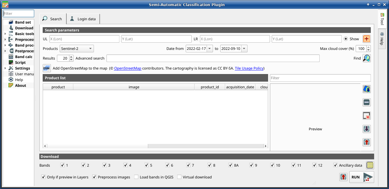
3.4.2.1. Search
The Search tool allows for searching and downloading:
Sentinel-2: Copernicus Sentinel-2 images (Level-1C and Level-2A) acquired from 2015 to present days;
Landsat_MPC: Landsat Collection images acquired from August 1982 to present days, such as Landsat 5, 7, 8, 9 (data retrieved from Microsoft Planetary Computer);
Sentinel-2_MPC: Copernicus Sentinel-2 Level-2A acquired from 2015 to present days (data retrieved from Microsoft Planetary Computer);
Landsat_HLS: Landsat from Harmonized Landsat Sentinel-2 by NASA which are surface reflectance data product (generated with Landsat 8, Landsat 9, and Sentinel-2 data acquired from 2013 to present days) with observations every two to three days at 30m spatial resolution (more information about the project);
Sentinel-2_HLS: Sentinel-2 from Harmonized Landsat Sentinel-2 by NASA which are surface reflectance data product (generated with Landsat 8, Landsat 9, and Sentinel-2 data acquired from 2013 to present days) with observations every two to three days at 30m spatial resolution (more information about the project);
MODIS_09Q1_MPC: MODIS Surface Reflectance 8-Day (250m) (data retrieved from Microsoft Planetary Computer);
MODIS_11A2_MPC: MODIS Land Surface Temperature 8-Day (data retrieved from Microsoft Planetary Computer);
ASTER_MPC: ASTER L1T (data retrieved from Microsoft Planetary Computer);
Copernicus_DEM_30_MPC: Copernicus DEM GLO-30 (data retrieved from Microsoft Planetary Computer);
The download of Harmonized Landsat Sentinel-2 requires credentials defined in Login data.
3.4.2.1.1. Search parameters
Define the search area by entering the coordinates (longitude and latitude) of
an Upper Left (UL) point and Lower Right (LR) point and select a
product to search.
Optional settings are date of acquisition, maximum cloud cover, number of
results (the fewer the results, the faster is the query).
The definition of a search area is required before searching the images.
Tool symbol and name |
Description |
|---|---|
UL |
set the UL longitude X (Lon) and the UL latitude Y (Lat) |
LR |
set the LR longitude X (Lon) and the LR latitude Y (Lat) |
|
show or hide the search area in the map; |
|
define a search area by left click to set the UL point and right click to set the LR point; the search area is displayed in the map |
Products |
set the search product |
Date from |
set the starting date of acquisition |
to |
set the ending date of acquisition |
Max cloud cover (%) |
maximum cloud cover in the product |
Results |
maximum number of products returned by the search |
Advanced search |
some services (e.g. Sentinel-2) allows for entering search parameters; for instance, it is possible to enter the name of a granule (e.g. 33TTG) |
Filter |
set a filter such as the Product ID (e.g. |
Find |
find the products in the search area; results are displayed inside the table in Product list; results are added to previous results |
|
this button allows for the display of OpenStreetMap tiles ( © OpenStreetMap contributors) in the QGIS map as described in https://wiki.openstreetmap.org/wiki/QGIS . The cartography is licensed as CC BY-SA (Tile Usage Policy ) |


Tip
Search results (and the number thereof) depend on the defined area extent and the range of dates. In order to get more results, perform multiple searches defining smaller area extent and narrow acquisition dates (from and to).
3.4.2.1.2. Product list
The table Product list contains the results of the search. Click on any item (highlight the item) to display the image preview thereof (not all the products include image previews). Resulting products are saved with the QGIS project.
The table includes the following fields.
product |
image |
product_id |
acquisition_date |
cloud_cover |
zone_path |
row |
min_lat |
min_lon |
max_lat |
max_lon |
collection |
size |
preview |
uid |
ref_url |
|---|---|---|---|---|---|---|---|---|---|---|---|---|---|---|---|
the product name (e.g., Sentinel-2) |
the image name |
the ID of the product |
the acquisition date of the product |
percentage of cloud cover in the product |
the zone or WRS path depending on the product type |
the WRS row |
minimum latitude of the product |
minimum longitude of the product |
maximum latitude of the product |
maximum longitude of the product |
collection code |
product size |
URL of the product preview |
identifier of the item |
reference URL |
The following tools are available.
Tool symbol and name |
Description |
|---|---|
|
display preview of highlighted images in the map; preview is roughly georeferenced on the fly (not all the products include a preview) |
|
remove highlighted images from the list |
|
remove all images from the list |
|
import the product list from an XML file |
|
export the product list to an XML file |


3.4.2.1.3. Download
Download the products in the Product list. During the download it is recommended not to interact with QGIS.
Depending on the download service, it is possible to select single bands for download.
Tool symbol and name |
Description |
|---|---|
|
select bands for download |
|
if checked, the metadata files are selected for download |
|
select or deselect all bands |
|
if checked, download only those images listed in Product list which are also listed in the QGIS layer panel |
|
if checked, bands are automatically converted after the download |
|
if checked, bands are loaded in QGIS after the download |
|
export the download links to a text file (.csv) |
RUN |
start the download process of all the products listed in Product list |


3.4.2.2. Login data
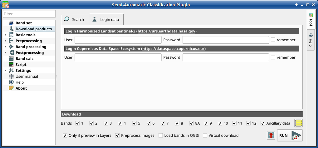
 Login data
3.4.2.2.1. Login Harmonized Landsat Sentinel-2
The download of Harmonized Landsat Sentinel-2 requires to login using EOSDIS Earthdata credentials (https://urs.earthdata.nasa.gov) One can register for free at https://urs.earthdata.nasa.gov/users/new .
Tool symbol and name |
Description |
|---|---|
User |
enter the user name |
Password |
enter the password |
|
if checked, remember user name and password locally in QGIS |

Warning
If  remember is checked, the password is stored
unencrypted in QGIS registry.
remember is checked, the password is stored
unencrypted in QGIS registry.
3.4.2.2.2. Login Copernicus Data Space Ecosystem
The download of Sentinel-2 is available also using Copernicus Data Space Ecosystem credentials (https://dataspace.copernicus.eu). One can register for free at https://dataspace.copernicus.eu .
Tool symbol and name |
Description |
|---|---|
User |
enter the user name |
Password |
enter the password |
|
if checked, remember user name and password locally in QGIS |
Warning
If remember is checked, the password is stored
unencrypted in QGIS registry.